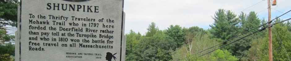
Or, as some called it, HOLD TIGHT & WORRY – officially the Hoosac Tunnel & Wilmington Railroad. Remember my last stay with Amos Brown in November? During that trip I got to the Hoosac Tunnel for the first time, and toured a different road down the Deerfield River. That was a great experience, and reviewing it now – I need to get back, but I did state then that this rail route needed more exploration, and that began today.
BLUE BELLE got inspected yesterday (I forgot this was her year, discovering that when ready to back out a week ago), and she wanted to get out. Eighteen miles an hour she averaged today for about 128 miles in over seven hours. Last night we had no real plans, but yesterday I also decided I needed a vintage RED Coleman Cooler for LADYRAB III. So, always seeming to end up in Vermont I thought the Wilmington Flea Market a potential, then looking at the maps for a circle and to “fill in the map” I realized I had not taken Route 8 south from Searsburg, and then playing with the maps I saw in fine print the “Glory Hole.” Remote – that had to be seen and shared. So, off BB2 and I went.
Route 9 was torn up from West Brat to almost Wilmington when I passed in May – it is still construction dirt. Even though we like dirt roads – construction dirt for mile after mile is bad – avoid it until repaired. The Wilmington Flea Market was nice, but only about half the vendors from what I have seen in the past – and there it was – BUT…

I waved my magic wand – I repeated all the magic words and spells I know – but alas, the almost perfect find did not turn red, but remained green. The vendor suggested a can of spray paint, “but I am an originalist,” I replied. The QUEST continues, so, HELP. Let me know when and where you see one for me (vintage please like above – they still make “new” ugh, ones) – all must be color coordinated RED in my “new” LADYRAB III.
So, now onto Hoot, Toot and Whistle discoveries. Below is the route I took today. I needed to find the Wilmington Station, and traverse the route from Readsboro to Whitingham – AND – discover the “Glory Hole.”

I brought along my $200 Volume One of THE COMING OF THE TRAIN, by Brian Donelson, to help in my search with its maps and photographs of this little rail line. Remember – “books are tools,” but also in the past decades have paid for my toys and trips.
At the light in the center of Wilmington (now a vacation ski town) I turned south and then right on Shaffer Street which the 1906 map in the book shows where the train depot and other buildings were located. I feel BLUE BELLE is parked in the spot where the station probably was. The buildings in the background are newer and a propane facility now.
I chatted with a fellow cutting grass, and he said he thought the building below (which I had to share) was part of the railroad, but the 1906 map shows it as a farmhouse at a distance from the rail lines. BUT, he told me of a tunnel I did not know about – “head out of town and turn at the green bridge he said. End of the road and a hike. There was a railroad bridge crossing the river at one time” he added – gone and “covered” with the creation of the reservoir which I learned happened in 1923.

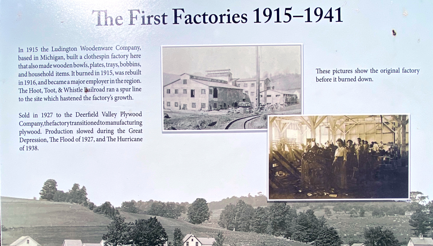
Next I explored the old mill area to the west and behind this “farmhouse” Hard to imagine the industry here in what is now just a resort town, but supported by the HOOT & TOOT and the lumber supply in the area. You can click to enlarge the below to learn.

Back heading west on Route 9, just past the Harriman Reservoir I saw the “green bridge” – actually an abandoned green bridge, with a new bridge to the east with green railings. Here is the bridge once across the river looking back at Route 9.

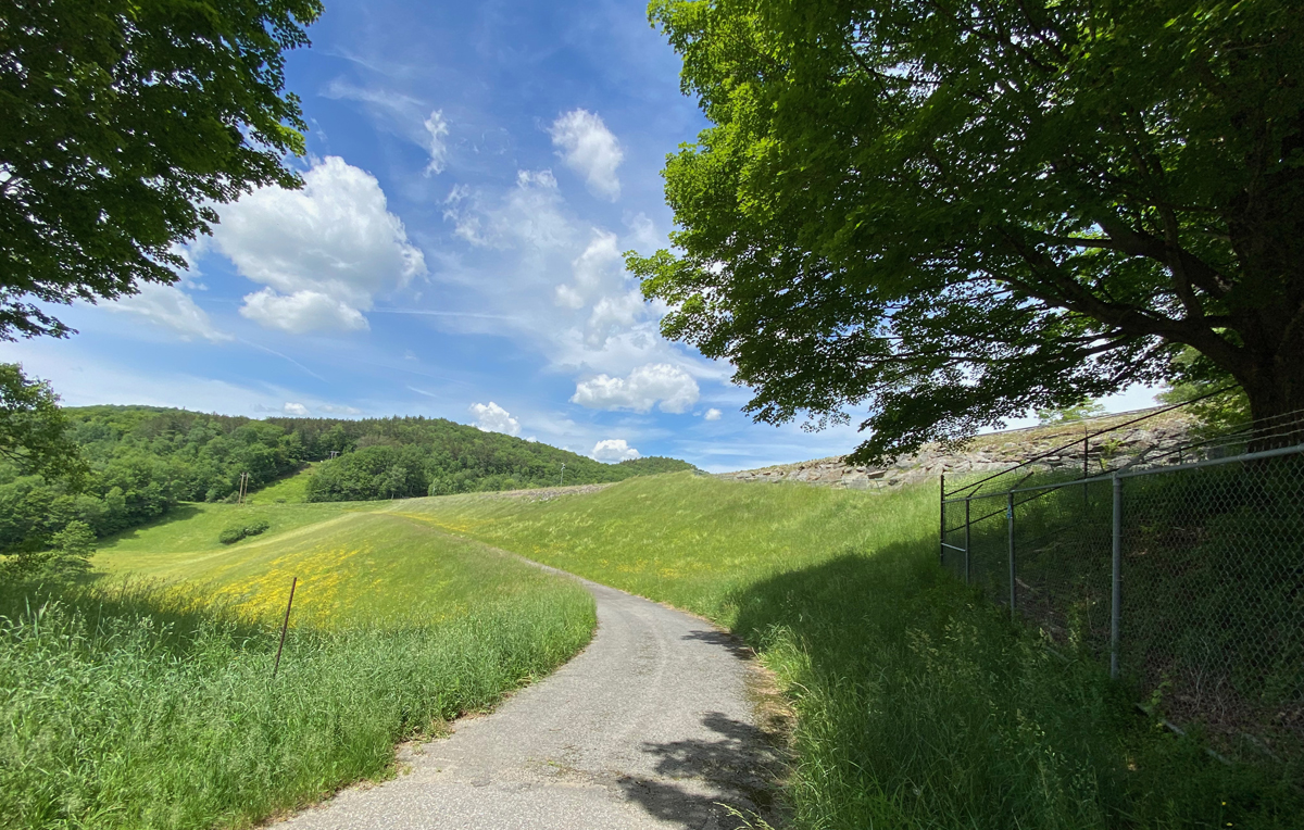
I then headed down the dirt road (did you know that BB1 and BB2 and I like dirt? yes you should). This was Woods Road leading to Mt Mills West Picnic Area – on the hydro project land. This was the site of the now gone, and water covered Mountain Mills, Vermont. BB2 and I parked where the road was blocked off.

And, believe it or not with my decrepit bones, I hiked for over ten minutes up what appeared to be the old rail line. Tempted with each bend that I would find the tunnel the fellow told me about, it was not to be. Going back downhill should have been faster, but not – so a nice 20-25 minute walk, no bears, but on return I did find what appeared to be part of the old railroad bridge across the original river.

Once your nose is trained, you can find treasures. Here in the woods on Woods Road in Wilmington I found this old gem, just waiting, and waiting…

Writing to remember, and to again enjoy, I started this post on Saturday night, but with intentions of finishing Sunday – so off it was to “Camp 44” for the night.

I sent this image to a few folks saying “good night” but in the house this morning, and adding it here, I noticed the light blue spot above the trailer. Too low for a real UFO, but has to be my “Guardian Angel,” and we know who. PS – nothing in that direction but thick pines. Upon study, it could have been caused by my lantern — BUT HOW? Must be a reflection off my “angel,” but it is reversed and upside down. Always with me.

Harriman Reservoir covered the rail route to Wilmington – and that led to research, and the small map reference to the “Glory Hole.” Looking at the map I saw Searsburg, Heartwellville, and Readsboro Falls – towns I did not recall transiting. So, a route was planned, and I can report that those towns exist only on maps and extremely easy to miss signs. No general stores for a bite to eat. The store fronts in Readsboro are now vacant, but I did get a wrap in the “new” general store, and enjoyed it overlooking a river – yes, at a picnic table
Heading east on Route 100, next comes Whitingham where the train also stopped at Davis Bridge. But from my maps I knew that just before the finger of the reservoir at Route 100 there would be a turn to my destination, and there it was, a small dirt (yeah) road with a very small sign – DAM RD. I drove to the end where there is a picnic spot beneath the dam, The trail map sign below gives an idea of the “lay of the land.” You may click to enlarge – the RED label (not a Coleman Cooler) indicates the location of the Dam and Glory Hole.

The road is at the lower finger of the water as the road takes a slight right up a hill. I thought it best to just provide you with this information from a website on the reservoir — “…the 217-foot-tall Harriman dam. Extending 1,250 feet across the Deerfield River Valley, the earthen dam impounds 38 billion gallons of water to create the 2,184-acre Lake Whitingham, named for the town and settlements it inundated. The dam is protected from high water by this unusual spillway (one of the first of its kind), which functions like an escape drain in a bathtub that allows water to exit before it overflows. The Glory Hole—a term that may have come from the miners who excavated the rock for the downstream outlet—is a 180-foot-deep concrete funnel whose 160-foot-diameter rim is set at the desired level for the lake. In the event of a flood, the overflow drains into the spillway at a rate of 30 million gallons per second and is safely discharged below the dam rather than over it; this became known as a “morning glory” design because it resembles a blossom when water spills over its face. This is critical here because earthen dams quickly erode and crumble if crested.” My images tell the rest of the story, and I hope you plan a visit.
and, below the “Glory Hole” – hopefully from a safe distance – but I doubt the chain link fence would stop a determined, or impaired driver.


I need to call the local historical society to find where the Whitingham “Hoot & Toot” station was, but I am betting it may be underwater. But while searching (on a back dirt road) I sniffed out another old treasure.

Continuing east to Jacksonville I need to ask where that station was as well. Continuing on the few back roads in Halifax (not Canada, but Vermont) I usually take a wrong turn, but eventually recognize a corner and correct myself to end up at one of my favorite places – Green River – where I sat with a bottle of water, learning you are invited to enjoy on the private property, but not picnic.

Continuing east on Stage Road towards US Route 5 at Guilford, at last I was here at the right time to enjoy some ice cream at the BLUEBERRY HAUS while BLUE BELLE looked on with a tear in her Grille. I will head back, even if a “dead head” trip.

North on US Route 5, and home. Home with memories, new explorations, and enjoyment writing to remember, and to share. Stay well and safe, as always, luv, RAY


What a fun adventure!! Will have to seek out the glory hole with our little Spyder.
Thanks for the travel tips Ray. I’ve only done Rte. 8 down to 8A, and then kept going on the latter. We’ll give it a whirl sometime.
I have often wondered if the Glory Hole dumps into that fantastic wooden sluice pipe, big enough to drive an MG thru, that runs down the south side of Rte. 9 out in that area of Wilmington & Searsburg.
An informed source told me to jest’ fuggedabout Rte.9 for a while, my son Patrick. That’s his project for Pike Industries.
No, the Glory Hole is at the south end of the reservoir. That big pipe on Route 9 seems to feed to the reservoir. A bookseller friend (now deceased) who lived in that last house facing the lake explained purpose, but now I forget — off to research – thanks, RAY
Seen at Dewey’s recently
>
Good report. Thanks Richard Schrum
thanks… I’ve travelled some of this… my mother was born in Wilmington in 1915 and lived in Mountain Mill.. her father worked logging… her family was moved out to make way for the flooding that produced the Harriman Reservoir.. in fact the 1920 census lists them as living on Boyd Hill Road… also, yesterday we went to the east portal of the Hoosac Tunnel. near that I found the very south end of the Hoot Toot and Whistle RR, it is gated but you can get past it and explore the south end of the old railroad bed…