I need to catch up with writing about past adventures, but best start is to begin with my recently completed adventure. Six years ago I started writing about my trips exploring the Erie Canal, but my interest goes back much further, Joining the Canal Society of New York State in 2019 I have been able to join their trips and learn more, and thus provide you with some of that adventure and learning. This “study tour” covered spots I have explored on my own, but it is so much better when you can tour with a focused group. This post may get long as I try to share history, but hopefully keep it brief to spur you to your own explorations – in the Mohawk Valley.
Within this stretch of the Mohawk Valley you can easily see all three stages of the Erie Canal. The engineering and construction solutions amaze me, and I need to learn more. Ironically, this morning as I sat down to write this, on Facebook the Erie Canalway National Heritage Corridor provided this background, which I will share, giving them the credit, of course.

Since its grand opening in 1825, the canal has been enlarged three times to accommodate larger boats and more traffic. Changes were made to the route and to canal structures like locks and bridges each time.
1825 – CLINTON’S DITCH: At just four feet deep and 40 feet wide, the original Erie Canal quickly became choked with boats. It was enlarged starting in 1826 and only a few original structures remain.

1836-1862 – ENLARGED ERIE: The Enlarged Erie built upon and improved the original. At seven feet deep and 70 feet wide, the canal could handle increased loads and traffic. If you’re looking at an old stone lock, canal wall, or aqueduct, it’s probably from the era of the Enlarged Erie.

1905-1918 – ERIE BARGE) CANAL: With the advent of motorized vessels, mules and towpaths were no longer needed along the canal. New York State enlarged the canals and moved some sections into rivers and lakes to create the New York State Barge Canal System. The structures and channels that operate today are largely unchanged from when the system went into operation in 1918.

The tour was on Saturday the 5th, but with preliminary explorations on Friday. I headed to Amsterdam, NY, on Thursday to be in position for the Friday informal explorations. Lodging was planned at the Amsterdam Castle – originally built in 1895 as a National Guard Armory. I needed to learn more. My son, Gary, and I call these research “rabbit holes.” Briefly a good number of these local armories were built in New York State following the Draft Riots in NY City in the 1860s and continuing with civil unrest between immigrant groups, religious factions and laborers in years following. The idea being the presence of the guard may lessen the chance of any civil unrest – the Armory here is prominent on a hill across the river from the large mills in Amsterdam. Please visit the National Guard Armory website where there is a great history is in the fourth paragraph down explain all this.
The exterior of the “castle” is little changed from the early 20th century postcard view above. The main floor drill area, however, has been transformed into a banquet hall, decorated with armor and other medieval accouterments.

some interesting areas reworked into suites, but on the second floor is this room where campaigning John F. Kennedy spoke September 29, 1960.

remember when you see my “side by side” galleries you can click for larger image views.


After settling in I headed out to explore awhile. Coming west from Ballston Spa I took NY 67 to Amsterdam. This evening I headed back east on 5S which I have not been on in this area. I first pulled into Lock 10.

turning around and heading back west I crossed the river to Tribes Hill and Lock 12 which I first visited in July 2019.

also on that July trip I first explored SCHOHARIE CROSSING STATE HISTORIC SITE – RAY RECOMMENDS – If you must limit your Erie Canal explorations this is where to come because you can experience all three iterations of the canal with remaining routes and structures in close proximity. You will see more about this area in this post, and in the July 2019 post I linked above.

FRIDAY APRIL 4 — I drove west towards Little Falls on 5S stopping in Danube to meet the group for the pre-tour adventures. Craig Williams, the president of the Society and who is a retired senior historian at the New York State Museum, is in the center introducing the first hike.

we crossed this bridge over a cut for water control, the destination the Rocky Rift Dam. Having had a fall 36 hours earlier, I did not make the entire walk to be safe.


Later we assembled on the west side of the Schoharie River (bottom of map on right), which is part of this amazing state historic area. Why you ask? With the canal shut down dams are open, winter waters flowing, and river levels down allowing Canal Fanatics the opportunity to explore under the famous enlarged canal Schoharie Creek Aqueduct to see the amazing workmanship. In the image to the right (with my WAZE app) you can see the creek and areas of the historic site. The museum is on Schoharie St. additional earlier canal remains in area of the “Florida” wording, and Lock 12 to the left after the road crosses the Mohawk River.
and, off we went down the dry creek bed.

as we approach the arches

here is the group – image from the Canal Society of New York State Facebook page —

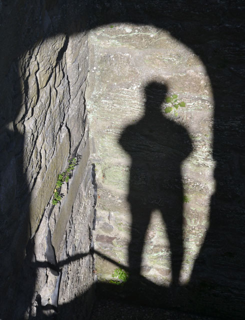
pointed out was the care the craftsmen took to match up the quarried stone graining, even though not a showpiece area.

the next two images illustrate the supporting areas for the tow path and the trough for the water. You can also see a cut out area for supports to hold the trough with its weighty water.


after years of my posts you should know I like (and have an eye out for) textures – shadows – and framing. Can’t get more texture with shadowing at once – or fun framing.


of the fourteen arches some had fallen, and others taken away so as to not hold back ice and flooding. No this is not a fallen Roman aqueduct, but New York grown and fallen.

the informal day concluded, I headed back to the Armory on the south side of the river, but first stopped at the park and footbridge across the river. In the top image you can see the old carpet mill on the hill in the background. Bottom image is looking east. Warning – in this area there is a definite lack of dining options.


Saturday the 5th (dreary with light rain – thus poor images) the tour bus was off at 8:30, our first stop was the Canal Corporation repair facility in Fonda. Bouys were stored on the shore and the banner above shows them lined up. I captured a similar image on the Oswego Canal trip in May of 2022.


of interest is this canal work tug. If I recall correctly it was built a few inches shorter than the length that the Coast Guard would require a licensed captain. A strange shape I had to share.

Next we arrived at the museum for SCHOHARIE CROSSING STATE HISTORIC SITE located on the east side of the creek.

you may enjoy enlarging these images to read the panels to learn how Hurricane Irene uncovered the original fort, outlined by the stones above.


I have taken days writing to remember this adventure, and keep finding more for further research and to share – AND, on my fifth day in pursuit of learning I found the YouTube channel for the Schoharie Crossing State Historic Site — yes, click that link for 51 videos including – Erie Canal: The Early Years w/ Craig Williams.
As I mentioned before – in this area you can see features of all three canal phases. With Clinton’s Ditch (1825) several creeks or rivers were crossed by building dams to create slack water flowing opposite the canal. Then there would be a gate (as in image below) in the canal to be opened when time for a canal boat to pass.

opposite the above is the creek, and you can see the remains of the stone dam that created the slack water. At the top left is the remnants of an early aqueduct.

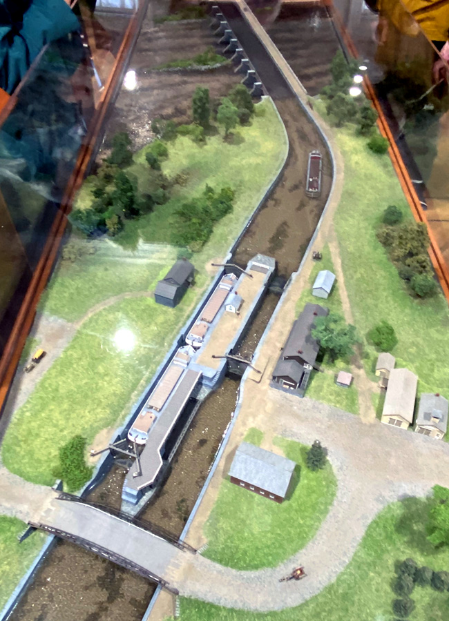
and, in the museum is this model of the large aqueduct from the Enlarged Canal construction. This is the aqueduct we explored yesterday, and later on below.
we then headed back over to the west side of the creek where yesterday we were under the aqueduct. Joining us was a site employee with the key to the gate and we were allowed to carefully traverse the tow path. Path on the left – trough for the canal boats on the right side (wood structures supported by piers long gone)


below you can see the museum in the background on the east side of the creek

on the west side the canal was constructed across fields with berms built up to hold the water and tow path. Imagine farming your land and looking up 20 to 30 feet and seeing a boat going by.

It was then back on the bus up onto the Thruway and a stop at the Mohawk Valley Welcome Center at milepost 187 when heading west. A great place to stop — and I have many times when cheating on the “super-slab” – the building was designed to look like a lock warehouse and has great exhibits. Outside a fun themed playground – and easy access and viewing of Lock 13 on the Barge Canal.
We continued west on the Thruway. At the museum is this early view (with some artistic license) of THE NOSES located near Sprakers. often referred to as the Gateway to the West (1614-1925). Little Nose is on the left – 414 feet high, and Big Nose on the right (north side of river). The Mohawk River flows between.

I took a picture from the bus, but could only capture the north Big Nose. Later I found in the Canal Society’s 2013 tour guide the below image, and received permission to share here. Route 5 on the right side of the river, and on the left side is the Thruway. The canals also ran on the south side as did the West Shore Railroad. Do click to enlarge for full impact.

Photo above from the late Thomas K. Grasso who was president of the canal society for over 30 years, and an accomplished geologist. You may recall I attended a five day seminar at Historic Deerfield on the geology of the Connecticut River Valley – and I cannot now look at “rock cuts” without wanting to know more. Well, again it is geology that allowed this passage west, and the means for canal construction, and later the railroad. While chasing another rabbit down a hole, I found this YouTube video by Grasso discussing the geology of the area. So, take the time and view and learn – click image.

A next stop was in Fort Plain on 5S. I had seen buildings built over locks, but Craig received permission for us to explore the property. From The Erie Canal Website – “Enlarged Erie Canal Lock No. 32 is located in Fort Plain, N.Y. at the east end of town on Route 5S. The lock is a double-chamber lock originally built about 1850, with the south chamber double-length, lengthened in 1888. Lock No. 32 currently has a garage and house built atop it. The lock runs through the basements of both the garage building and the house to the west and across the front yard of the house.” Below and filled in are the top stones of one of the locks.

As traffic increased, with as many as 200 boats a day, many of the locking locations added a second lock to facilitate two way traffic. Usually the east bound locks were longer for larger loads of goods heading to New York City. In the old postcard below you can see the newer longer and larger lock on the left. Note the partial building on the right side – more about this later.

Below the right hand lock (as seen above) — the house on the left has the newer lock as a basement.

long view of both locks – was overcast and raining thus not great images.

inside the larger lock on the south side closest to 5S

the stonework at the east end of this lock


you can make out the foundation of the canal store I mentioned above. Deteriorated, disassembled, and put in storage by the state museum years ago, Fort Plain asked for it, got remaining pieces back, and is preparing an exhibit…

inside this building…

a model of the store that was along the canal

the facade is being recreated inside to the left – I will have to visit this interpretive exhibit when finished.

On 4 May this post and image appeared on Facebook, and I thought it fun to share here: Fred Fineour’s canal store was located at the end of present day State Street by the old Erie Canal lock 32. Canal boats stopped here to stock up on necessities as the boats made their way along the canal. In the 1980’s the State Museum in Albany dismantled the store and removed it to their warehouse with the thought of reconstructing a part of it at the museum in Albany. That never happened and the state returned the storefront to the Friends of Fort Plain where it is presently being erected inside 47 Main Street.

below is Lock 15

heading west to Dump Road on the south side of the river across from St. Johnsville is old Lock 33. Used as a dump for ages, it was cleaned out beginning in 1999. On a clearer day in 2022 I visited here, and you may wish to see my images from that visit.

You have to know where to look — and on the opposite bank, hidden by the branches are aqueduct remains from Clinton’s Ditch in Sprakers.

WOW – a full day, after dinner a great evening program on the GUY PARK MANOR adjoining the Mohawk River damaged by flooding and its restoration.
If you made it here, I applaud and thank you. Documenting these memories took me over several days as I kept finding more things I needed to learn more about, and then included those links in case you wish to dig further. – Yours, RAY
RAY RECOMMENDS
1 – Explore this section of the Mohawk Valley and its history
2 – Let those explorations expand from one tidbit to another – follow those rabbit holes
3 – Learn about the Erie Canal, its impact on our nation, and marvel at its engineering feats and what remains after 100-200 years.
12 April — this just popped up on my Facebook feed — looks like a great history series – I will watch later today – looks like great history and images – click below and give it a try. NOTE – if you click the > at the bottom of the first video you will get the chapter list on the right.